Canada
Legal alcohol on the Canadian side stood close to a major American city where sale, manufacture and transportation had been outlawed.
03 · EXPLORE DETROIT
Border. Lifeline. Working waterway.
A line through the middle of Detroit's story.
FOLLOW THE WATER ↓
DETROIT BEGINS AT THE WATER
The Detroit River carried freight, workers, industry, passengers and opportunity. It also became a border to patrol, a route to cross, and during Prohibition, a corridor for illegal liquor moving toward Detroit.
THE WORKING RIVER
Commerce moved through the city on water long before Ralph Palmer carried a badge.
THE BORDER
Two shorelines facing one another across an international boundary.
THE 1920s
Boats, winter crossings, smuggling and enforcement reshaped the river after dark.
INDUSTRIAL DETROIT
Docks, factories, rail and shipping connected Detroit to a larger industrial machine.
A CITY CONNECTED
The skyline gained two permanent international crossings as Detroit entered a new era.
LAW & THE WATER
Customs, local police and federal enforcement all met along the same river.
01 · THE WORKING RIVER
The riverfront was never merely a view. Freighters, docks, rail connections and industrial traffic made it part of the city's daily machinery. The shoreline linked Detroit to regional and international commerce while the city expanded inland.
02 · THE BORDER
The opposite shore was close enough to see, but legally another country. That proximity shaped commerce, travel, policing and eventually the mythology and reality of Prohibition-era smuggling.
SCHEMATIC · NOT TO SCALE
THE RIVER BECOMES A ROUTE
Prohibition did not create Detroit’s border, docks, roads or drinking culture. It changed what could move through them legally—and made the city’s geography part of the crime.
Legal alcohol on the Canadian side stood close to a major American city where sale, manufacture and transportation had been outlawed.
Rum-runners used the river and established crossings to move liquor toward Detroit while customs and law-enforcement agencies worked the same geography.
Once ashore, automobiles and local routes could carry illegal liquor away from the waterfront and into the city.
Detroit’s name for speakeasies covered illegal drinking places ranging from concealed rooms to businesses and homes.
WHAT THIS IS: a documented general pathway through the border city. WHAT THIS IS NOT: a claim that every shipment followed one route or that an unverified location was a crime scene.
This section draws on Detroit Historical Society material about Detroit under Prohibition and The Henry Ford’s collection history of bootleg liquor.
EXPLORE PROHIBITION DETROIT →READ OUR PROHIBITION RESEARCH →03 · PROHIBITION DETROIT
During Prohibition, Detroit's closeness to Canada made the river a natural route for illicit liquor. Warm months meant boats. Winter could change the crossing entirely. The history belongs here because it helps explain the city that later generations of Detroit police inherited.
PROHIBITION RIVER HISTORY · DOCUMENTED SOURCES ONLYA DIFFERENT KIND OF CITY MAP
Docks, international crossings, industrial sites and enforcement points make the river a geographic thread through Detroit history. The map stays broad here so only verified locations are presented as specific historical sites.
04 · WATER & STEEL
Factories, warehouses, rail lines and shipping infrastructure grew around the same geography. As the automobile industry transformed Detroit, the river remained one of the city's great working corridors.
05 · INTERNATIONAL CROSSINGS
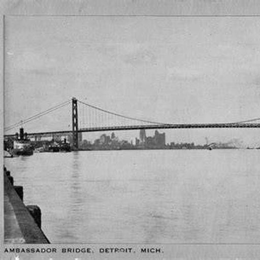
By the end of the 1920s and beginning of the 1930s, permanent international crossings changed how Detroit and Windsor connected. The Ambassador Bridge and Detroit-Windsor Tunnel are treated as distinct historical crossings, with detail limited to material that has been verified.
Historical file: construction, opening, traffic and changing river geography.
Historical file: downtown crossing, border traffic and the international city beneath the river.
06 · LAW & THE WATER
Local police, customs authorities, and federal enforcement did not all have the same responsibilities. This section keeps those roles separate and connects river-related cases to Detroit Police history only where the record supports the connection.
THE WORLD KEEPS OPENING
The River connects naturally to Streets & Crime Crawl, Detroit After Dark, Prohibition history, industrial Detroit and the newspaper archive.
THE STREETS →BACK TO EXPLORE DETROIT →Solve Monthly Crime 01 · The Missing Shield · Evidence 04 of 05
The first letter of each line names the day:
CONTINUE IN THIS CATEGORY